1974년 7월 20일 터키가 북키프로스에 상륙해 북쪽 절반을 접수했을 당시 미국 첩보위성들이 촬영한 사진들이 공개됐네요. 당시엔 필름촬영위성들만 떠 있어서 실시간으로 확인하진 못했다고 합니다.
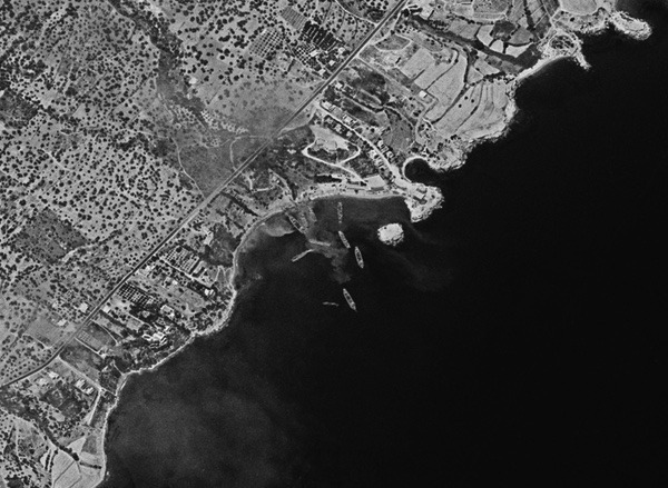
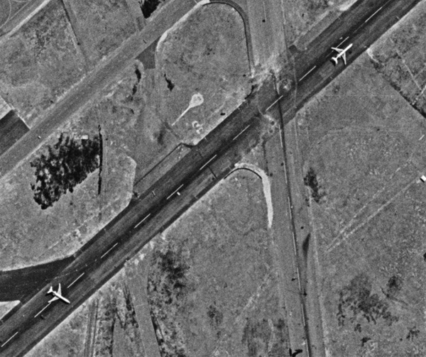
키프로스 1974년 7월 20일 아침, 터키 군대가 키프로스를 침공하여 북부 해안 키레니아에 상륙했다. 여기서 여러 상륙정이 병력을 하역하는 모습이 보인다. (출처: Harry Stranger 경유)
키프로스 1974: 냉전기 위성 정찰과 주변 전쟁 드웨인 A. 데이, 해리 스트레인저 2025년 9월 2일 화요일
동지중해의 정치는, 완곡하게 말하자면, 복잡하다. 수천 년 동안 분쟁의 핵심 지역 중 하나였던 곳이 바로 키프로스 섬이다. 키프로스는 지중해에서 세 번째로 큰 섬으로, 터키에서 남쪽으로 65km, 시리아에서 서쪽으로 100km, 그리스 본토에서 남동쪽으로 800km 떨어진 동지중해에 위치해 있다. 수도는 니코시아다. 이곳에는 중요한 영국 신호정보 기지와 영국군이 주둔하고 있다.
1974년 여름, 이전 충돌로부터 10년 뒤 키프로스는 다시 불붙었다. 수년간의 불안정한 평온이 갑작스러운 격전으로 폭발했고, 두 나토 동맹국이 섬의 통제권을 두고 싸웠다. 그리고 미국 위성들이 상공에서 이를 지켜보고 있었다. 이제 처음으로, 그 분쟁의 위성 사진이 공개되었다.
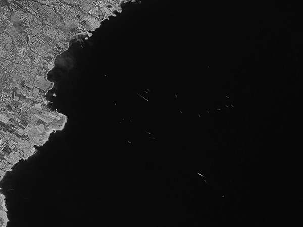
키프로스 키프로스 침공 당시 해안에 다수의 선박이 정박해 있다. 이 이미지는 침공 당일 HEXAGON 정찰위성이 촬영했으나, 지상에서 확인된 것은 전투가 끝난 뒤였다. (출처: Harry Stranger 경유)
이 섬의 이름은 구리의 그리스어인 “kypros”에서 유래했다. 섬에는 구리를 비롯한 광물 자원과 농경지 및 방목지가 있었다. 그리스와 터키는 오랜 라이벌이었고, 두 나라 국민이 키프로스에 거주했으며 다수는 그리스계였다. 정치 상황은 복잡했고, 유엔 평화유지군과 영국군도 키프로스에 주둔했다. 그리스 군사 정권은 키프로스 대통령 마카리오스 3세 대주교에 대한 쿠데타를 지시하고 니코스 삼프손을 세웠다. 터키 정부는 미국이 쿠데타를 막아줄 것이라 기대했으나, 리처드 닉슨은 워터게이트 스캔들의 막바지에 있었고 개입하지 않았다. 그 결과는 미국에 불리하게 작용했다.
1974년 7월 20일 토요일 새벽, 터키군은 북부 해안 키레니아(기르네)에 상륙해 그리스 및 그리스계 키프로스군과 맞붙었다. 터키는 자국계 키프로스인을 보호하고 키프로스의 독립을 보장한다는 명분을 내세웠다. 유엔 안전보장이사회는 이틀 뒤 휴전을 이끌어냈으며, 그 시점에는 터키군이 이미 키레니아에서 니코시아로 이어지는 좁은 길을 장악한 상태였다.
그러나 휴전은 불안정했고, 3주 뒤 터키는 2차 침공을 감행해 키프로스의 37%를 점령했다. 1974년의 휴전선은 섬을 두 공동체로 나누며 오늘날까지 “그린 라인”으로 불린다.
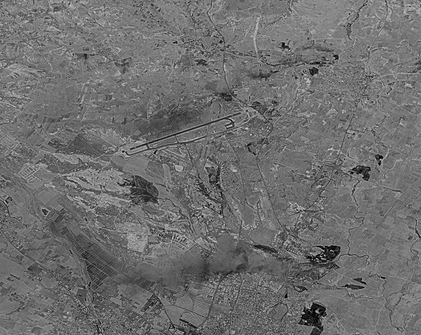
키프로스 1974년 7월 20일 터키군은 키프로스를 침공해 니코시아와 그 공항으로 향했다. 침공이 시작된 뒤 HEXAGON 정찰위성이 촬영한 사진에 다수의 화재가 보인다. (출처: Harry Stranger 경유)
그리스와 터키 모두 당시 나토 회원국이었기에, 미 해군은 지중해에 주요 전력을 배치하고 있었고, 영국군도 섬에 주둔하고 있었다. 따라서 침공에 관한 정보는 상당했다. 미국은 군사 활동에 대한 신호정보(SIGINT)를 확보했을 가능성이 크지만, SIGINT는 상대가 감청을 의식할 경우 한계가 있다. 침공은 너무 빠르게 전개되었고 초반 교전은 곧 끝났기에, 유입되는 정보를 따라잡기조차 어려웠을 것이다.
미국이 갖추지 못한 것은 침공 당시의 실시간 상공 사진정찰 이미지였다. 미 해군은 동지중해에서 정기적으로 작전을 수행했으며 전술정찰기들을 보유했지만, 키프로스 상공에서 촬영했다는 기록은 없으며, 양측 모두 미국산 항공기와 무기를 운용하고 있는 전쟁 지역에서 그런 임무는 위험했을 것이다. 실시간 위성정찰 기술은 막 발전 중이었으나 아직 운용 단계에 이르지 못했다.
그러나 미국이 보유한 것은 필름 카메라를 장착한 위성이었다. 1974년 4월 10일, 미 공군은 캘리포니아 반덴버그 공군기지에서 HEXAGON 임무 1208을 발사했다. HEXAGON은 넓은 지역을 한 번에 촬영할 수 있는 두 개의 강력한 카메라를 탑재해 전장을 ‘신의 눈’처럼 내려다볼 수 있었다. 1974년 6월 6일에는 GAMBIT 임무 4342가 발사되었다. GAMBIT은 하나의 초고해상도 카메라를 장착해 HEXAGON보다 좁은 지역을 촬영했지만 특정 차량과 군 장비를 식별할 수 있을 정도의 세밀한 이미지를 제공했다.
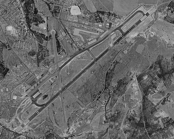
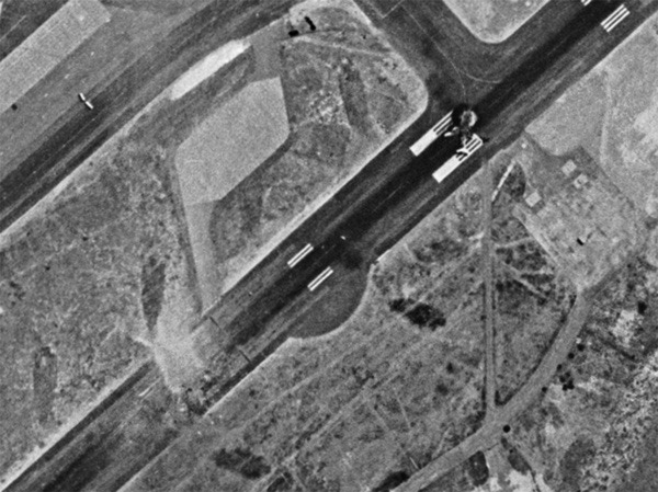
키프로스 니코시아 공항은 터키와 그리스군 모두의 주요 목표였다. 터키 공군은 그리스군이 사용하지 못하도록 공항을 폭격했다. 활주로에는 여러 대의 여객기가 있었으며 사진 속에 보인다. 이 사진은 7월 24일 휴전 이후 촬영되었다. (출처: Harry Stranger 경유)
HEXAGON과 GAMBIT 모두 침공 당시 궤도에 있었다. 하지만 위성은 필름을 사용했기에, 촬영 후 필름을 대기권 재돌입 캡슐에 담아 북태평양 상공에서 회수하고, 하와이와 캘리포니아를 거쳐 뉴욕 로체스터로 보내 현상한 뒤 워싱턴 DC로 전달해야 했다. 그곳에서 전문 판독관들이 현미경으로 이미지를 판독했다. 따라서 사진이 촬영된 순간부터 지상에서 확인되기까지 며칠에서 몇 주가 걸렸다. 침공과 같은 급박한 사건의 경우, 필름은 이미 상황이 끝난 뒤에야 도착했다.
7월 19일, 터키군 공격을 우려한 키프로스군은 니코시아 공항 주위에 방어선을 구축하라는 명령을 받았다. 7월 20일, 터키군이 침공을 시작하면서 터키 항공기들이 공항 폭격을 시작했다.
7월 21일 아침에도 터키 항공기는 공항을 다시 공격했다. 같은 날, 그리스 공군기가 수다 공군기지에서 이륙해 니코시아로 향했다. 두 대는 귀환했지만, 열세 대는 계속 비행했다. 7월 22일 새벽, 그들은 착륙을 시작했으나, 한 대는 키프로스군이 터키군으로 오인해 오인사격을 받아 격추되었다.
키프로스 터키 공군은 공항을 일시적으로 무력화하는 데 성공했다. 활주로에는 여러 개의 폭탄구멍이 보인다. 활주로는 파괴된 트라이던트 여객기에 의해 막히기도 했다. (출처: Harry Stranger 경유)
7월 22일, 양측은 휴전에 합의했다. 그러나 터키 공군은 휴전 직전 공항을 폭격해 활주로에 피해를 입혔다. 휴전 발효 후에도, 터키 공군은 미국제 F-100 슈퍼 세이버 전투기 2대와 F-104 스타파이터 전투기 6대를 동원해 공항을 다시 공격했고, 활주로에 있던 키프로스 항공 소속 트라이던트 여객기를 파괴했다.
7월 23일에는 공항에서 소규모 지상전이 발생했다. 또 다른 트라이던트기는 손상되었으나 불타지는 않았다. 50년이 지난 후에도 그 항공기는 폐쇄된 공항 부지에 방치되어 있었다. 두 대의 다른 트라이던트기는 경미한 손상을 입었지만 공항에 묶여 있다가 나중에 이륙해 철수했다. 그중 한 대는 현재 박물관에 전시되어 있다.
학교버스 크기의 HEXAGON 정찰위성은 7월 20일 키프로스 상공을 지나며 상륙 부대를 촬영했고, 7월 24일에는 공항을 촬영했다. 사진은 며칠 뒤에야 지상으로 돌아왔다. 사진에는 키레니아의 침공군, 섬 곳곳의 화재, 그리고 활주로 위에서 여전히 타고 있는 트라이던트 여객기의 잔해가 보인다.
키프로스 7월 24일 HEXAGON 정찰위성이 촬영한 사진에는 여전히 불타고 있는 트라이던트 여객기가 니코시아 공항 활주로 위에 보인다. 공항은 1974년 7월 20일 터키군 침공 이후 여러 차례 공격을 받았다. (출처: Harry Stranger 경유)
고해상도 GAMBIT 위성이 전투 중 키프로스를 촬영했는지는 알려지지 않았다. 시기적절한 영상이 없더라도, 미국은 전투에 관한 상당한 정보를 다른 방식으로 확보했을 것이다. 그러나 위성정찰은 군대가 어디에 배치되어 무엇을 하는지를 정확히 보여준다. 미국이 근실시간 위성정찰을 보유하게 된 것은 16개월 뒤인 1976년 말 KH-11 KENNEN 위성의 등장 이후였다.
닉슨은 8월 9일 사임했으며, 관련된 다른 정부들 또한 불안정했다. 8월 터키의 2차 침공 시점에는 그리스 군사정권이 붕괴 직전이었다. 영국 정부도 의회가 분열되어 개입을 꺼리고 있었다. 이 분쟁의 정치적 여파는 미국에 불리했다. 터키 정부는 미국이 그리스의 섬 장악을 막아주길 기대했다. 그러나 미국 정부가 그러지 못하자 터키는 침공을 단행했고, 동시에 터키 내 다수의 미군 기지, 특히 정보수집 기지를 중단시켰다. 헨리 키신저 국무장관은 이를 “재앙”이라 불렀다. 이후 키프로스에 있는 영국 감청 기지가 미국을 대신해 훨씬 더 큰 정보수집 임무를 맡게 되었다.
세계의 다른 지역에서는 거의 잊혔지만, 반세기 전 키프로스 침공의 여파는 오늘날까지 섬 주민들에게 영향을 미치고 있다. HEXAGON의 사진은 동지중해가 얼마나 자주 분쟁의 무대였는지를 상기시킨다.
추가 읽을거리:
터키의 키프로스 침공 CIA, “Reported Movements of Greek and Turkish Forces Toward Cyprus,” 1974년 7월 16일 국가정보일일보고, 1974년 7월 17일 대통령 일일보고, 1974년 7월 22일 대통령 일일보고, 1974년 7월 24일 CIA, “Status of Nicosia International Airport,” 1974년 7월 24일 대통령 일일보고, 1974년 7월 30일
드웨인 데이와 해리 스트레인저는 냉전기의 역사적 사건들을 해제된 위성 이미지를 활용해 재구성하는 작업을 해오고 있다. 드웨인 데이에게는 zirconic1@cox.net 으로 연락할 수 있다. 해리 스트레인저의 웹사이트는 https://spacefromspace.com/ 이다.
The Space Review: Flashpoint Cyprus 1974: Cold War satellite reconnaissance and peripheral wars

 |
Flashpoint Cyprus 1974: Cold War satellite reconnaissance and peripheral warsby Dwayne A. Day and Harry Stranger
Tuesday, September 2, 2025
The politics of the Eastern Mediterranean are, to put it mildly, complex, and one of the key areas of dispute over millennia has been the island of Cyprus. It is the third largest island in the Mediterranean Sea, located in the eastern Mediterranean 65 kilometers south of Turkey, 100 kilometers west of Syria, and 800 kilometers southeast of mainland Greece. The capital is Nicosia. An important British signals intelligence base and accompanying British forces are located there.
In summer 1974, Cyprus heated up a decade after a previous clash. Years of unstable calm erupted into a sudden flashpoint as two NATO allies fought for control of the island. And American satellites were watching from overhead. Now, for the first time, satellite photos of the conflict have been made public.
 |
The island derives its name from the Greek word for copper, “kypros,” which is present on the island along with other mineral resources as well as farm and grazing land. Greece and Turkey have long been rivals, and both countries had nationals living on Cyprus, with the majority being ethnic Greek. The political situation was complicated, and a United Nations peacekeeping force was also present on Cyprus, as were British military forces. The military junta in Greece ordered a coup against Cypriot president Archbishop Makarios III and installed Nikos Sampson. The Turkish government had expected the United States to prevent the coup, but Richard Nixon was in the final throes of the Watergate scandal and did not intervene. The results were not beneficial for the United States.
On Saturday, July 20, 1974, Turkish forces invaded Cyprus before dawn at Kyrenia (Girne) on the northern coast, meeting resistance from Greek and Greek Cypriot forces. Turkey claimed that it was protecting the Turkish Cypriots and guaranteeing the independence of Cyprus. The United Nations Security Council obtained a ceasefire two days later, by which time Turkish forces were in command of a narrow path between Kyrenia and Nicosia.
The ceasefire was tenuous, however, and three weeks later Turkey launched a second invasion, resulting in Turkey occupying 37% of Cyprus. A ceasefire line from 1974 separates the two communities on the island and is commonly referred to as the Green Line.
 |
Because both Greece and Turkey were members of NATO at the time, the United States Navy had a major presence in the Mediterranean, and the United Kingdom had forces on the island, there was substantial intelligence information about the invasion. The United States almost certainly had signals intelligence about the military activities, although SIGINT has its limitations, especially if an adversary knows somebody may be listening. The invasion happened so quickly, and the first action was over so soon, that it was undoubtedly difficult to keep up with the information that was flowing in.
What the United States apparently did not have was timely overhead photo-reconnaissance imagery of the invasion. The US Navy regularly operated in the Eastern Mediterranean and had tactical reconnaissance planes. But there is no indication that American aircraft were flying over Cyprus taking photos, and such missions would have been dangerous in a war zone, especially with both Greece and Turkey equipped with American aircraft and weapons. Near-real-time satellite reconnaissance technology was catching up but had not reached operational status.
What the United States did have, however, were satellites equipped with film. On April 10, 1974, the Air Force launched HEXAGON Mission 1208 from Vandenberg Air Force Base in California. The HEXAGON had two powerful cameras that could photograph large amounts of territory in a single sweep, providing a “god’s eye view” of a battlefield. On June 6, 1974, the Air Force launched GAMBIT Mission 4342 from Vandenberg. GAMBIT had a single incredibly powerful camera. It photographed a much smaller area than HEXAGON, but provided high-resolution detail enabling photo-interpreters to identify specific types of vehicles and military equipment.
 |
Both HEXAGON and GAMBIT were in orbit when the Cyprus invasion occurred. But because the satellites used film to record their images, this film had to be jettisoned in a reentry vehicle, recovered over the North Pacific Ocean, transported to Hawaii, then California, then Rochester, New York, for processing, and then delivered to Washington, DC, where trained interpreters looked at it through microscopes to identify military forces and equipment. It could take from days to weeks between when an image was taken and when it was seen on the ground. For fast-moving events like the invasion, the film arrived in Washington after the drama was over.
On July 19, concerned about a Turkish military attack, a Cypriot force was ordered to make a perimeter around Nicosia Airport. On July 20, as the Turkish forces began their invasion, Turkish planes also started bombing the airport.
On the morning of July 21, Turkish aircraft again attacked the airport. That same day, Greek military aircraft took off from Souda Air Force Base and headed toward Nicosia. Two of the planes diverted, but thirteen continued on. Early in the morning of July 22, they began landing at the airport, but one was shot down by mistake by friendly Cypriot forces who believed it was part of the Turkish invasion.
 |
On July 22, the two sides agreed to a ceasefire. But the Turkish Air Force attacked the airport before the ceasefire, bombing the runway. After the ceasefire took effect, the Turkish Air Force, using two American-made F-100 Super Sabre and six F-104 Starfighter jets attacked the airport again, destroying a Cyprus Airways Trident passenger jet on the runway.
Small-scale ground fighting took place at the airport on July 23. Another Trident was damaged at some point, although it did not burn. Fifty years later it was still sitting on the long-abandoned airport grounds. Two other Tridents suffered minor damage, but were stranded at the airport until later flown out. One of them< a href="https://www.youtube.com/watch?v=VxIyQCAQi7g">now resides in a museum.
The HEXAGON reconnaissance satellite, the size of a school bus, flew over Cyprus on July 20 and photographed the landing force. On July 24, it photographed the airport. The photos were not returned to Earth until days later. Its photos show the invasion force in Kyrenia, burning structures at several locations on the island, and the still-burning wreckage of the Trident airliner on the runway.
 |
It is unknown if the high-resolution GAMBIT satellite also photographed Cyprus during the battle. Even without timely imagery, the United States would have had substantial other intelligence about the fighting, including signals intelligence intercepts, but satellite reconnaissance can show exactly where a military force is operating and what it is doing. Near-real-time satellite reconnaissance would not become available to the United States for another 16 months, with the debut of the KH-11 KENNEN satellite in late 1976.
Nixon resigned August 9, but other involved governments were also unstable. By the time of Turkey’s second invasion in August, the Greek military junta was imploding. The British government was also wobbly, suffering a hung Parliament, and unwilling to intervene. The political repercussions of the dispute were bad for the United States. Turkey’s government expected the United States to prevent Greece from taking over the island. When the American government failed to do so, Turkey invaded, and also halted activities at numerous American military bases throughout Turkey, including intelligence collection sites, a result that Secretary of State Henry Kissinger called “a disaster.” Afterwards, the British listening post on Cyprus assumed a much greater burden of intelligence gathering on behalf of the United States. (See: “Stonehouse: Deep space listening in the high desert,” The Space Review, May 8, 2023.)
Although largely forgotten by the rest of the world, the fallout from the Cyprus invasion over a half century ago affects the island’s inhabitants every single day. The HEXAGON’s photos are a reminder that the Eastern Mediterranean has often been the site of conflict.
Further reading:
- Turkish invasion of Cyprus.
- CIA, “Reported Movements of Greek and Turkish Forces Toward Cyprus,” July 16, 1974. CIA-RDP78S01932A000100070050-6
- National Intelligence Bulletin, July 17, 1974. CIA-RDP79T00975A026700010050-0
- The President’s Daily Brief, July 22, 1974. CIA-RDP79T00936A012200010019-1
- The President’s Daily Brief, July 24, 1974. CIA-RDP79T00936A012200010021-8
- CIA, “Status of Nicosia International Airport,” July 24, 1974. CIA-RDP78S01932A000100070077-7
- The President’s Daily Brief, July 30, 1974. CIA-RDP79T00936A012200010026-3
Dwayne Day and Harry Stranger have been working on illustrating Cold War historical events using declassified satellite imagery. Dwayne Day can be reached at zirconic1@cox.net. Harry Stranger’s website is https://spacefromspace.com/.
Note: we are now moderating comments. There will be a delay in posting comments and no guarantee that all submitted comments will be posted.